Applied Meteorology Programs
Savannah River National Laboratory
Applied Meteorology Programs
The Savannah River National Laboratory (SRNL) Applied Meteorology Program helps ensure that the Savannah River Site (SRS) is operating in compliance with stringent environmental regulations.
Components of this program includes the collection, archival, and application of SRS meteorological data, and the development and application of technology to predict the transport and consequence of accidental hazardous material release to the air or surface waters. The tailored meteorological forecasts for site-wide response to severe weather events, planning weather-sensitive work, and prescribed burning in forested lands is crucial to safe site operations.
The Applied Meteorology Program also provides expert consultation on technical issues related to the fate of air or water-borne contaminants, air quality and environmental impacts assessments, and the characterization of current and future climatic conditions that affect facility design and operation.
SRNL Fast Facts
- National Laboratory for DOE Office of Environmental Management
- Supporting customers at SRS, DOE and other federal agencies nationally and internationally
- Applied research, development and deployment of practical, high-value and cost-effective technology solutions in the areas of national security, clean energy and environmental stewardship
- Operated by Battelle Savannah River Alliance
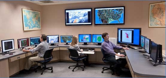
Meteorological Monitoring
At SRS, a network of instrumented towers provides reliable, real-time collection of meteorological data used for emergency response, design safety analysis, environmental impact assessments, and air quality compliance. Monitoring towers are adjacent to each of the eight major SRS operations areas, and collect data on wind speed, wind direction, temperature, and humidity. Measurements from a ninth tower located near the center of SRS include precipitation, solar and terrestrial radiation, barometric pressure, soil temperature and evaporation.
Additional monitoring systems include:
- Visibility and cloud height measurements for security force aviation needs
- Soil moisture and precipitation at various locations supporting forest and pollution discharge management
- Wind, temperature and moisture measurements from multiple levels of a nearby TV tower for SRS emergency response and SRNL atmospheric research programs
- Wind, temperature and humidity from three industrial corridors in Augusta, Ga., as part of a mutual aid agreement with the Augusta/Richmond County Emergency Management Office
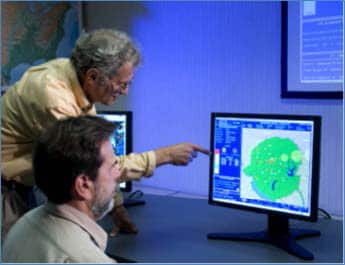
Atmospheric Technology Center
The Atmospheric Technology Center (ATC) is equipped to access regional, national, and international meteorological observations, analysis and forecasts through the National Weather Service for supporting SRS operations and work for other programs. SRNL meteorologists use these resources to develop forecasts and analyses for to safe and effective site operations:
- Severe weather (hurricanes, thunderstorms, tornadoes, high winds, rain, etc.)
- Routine forecasts of wind, precipitation, heat and cold stress for routine outdoor work
- Fire weather forecasts for USDA Forest Service-Savannah River prescribed fire program
SRNL, in conjunction with the SRS Operations Center, has implemented a means for automated pager notifications to remote workers following receipt of National Weather Service severe weather warnings and lightning strikes. This automated system provides an additional 20 minutes of response time to a severe weather event. In addition, SRNL provides current weather observations and forecasts of general need to the SRS workforce through the SRS intranet (InSite).
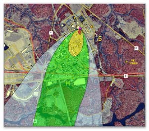
Atmospheric and Surface Water Transport Modeling for Emergency Response
For nearly 40 years, SRNL has been a leader in developing emergency response technology. The Weather INformation and Display (WIND) System is a computer-based resource for predicting the effects of hazardous material releases to the environment. The WIND System was developed at SRNL and seamlessly integrates real-time SRS meteorological observations and detailed forecasts with a suite of environmental transport and dispersion models. These models can be used to predict potential hazards on local and regional levels. These predictions include a variety of human exposure scenarios applicable to the hazardous materials handled at SRS. WIND System modeling was also a vital tool used to support state and local officials during a major chlorine release in the town of Graniteville, S.C., in 2005.
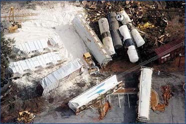
2005 Graniteville, S.C., train wreck that resulted in a major chlorine release.
Download Fact Sheet
Contact Information
Steve Chiswell
803.725.9488
steven.chiswell@srnl.doe.gov